This winter’s excellent snowpack is turning into runoff and our local rivers are running high. Spring runoff’s impact on river flows, both timing and magnitude, depends on whether the river is a Tailwater River (below a dam, like the Lower Boise River through town), a Freestone River (naturally flowing like the Middle Fork of the Boise River) or a Spring Creek (like Silver Creek). Spring river flows can be dangerous, so it is important to know the river before you venture out. Both the Lower Boise River in town and the South Fork of the Boise River become dangerous to wade when flows rise above 600cfs. Flows on the Owyhee below the dam have started to come up and with the reservoir filling should reach normal 200cfs flows this summer, which is a very wadable level. Checking river flows on BVFF’s Local Waters page is an important part of planning your fishing trip.
TAILWATER RIVERS
Our Tailwater rivers are primarily managed for irrigation and flood control and spring flows below the dam depend on both the snowpack and the reservoir carryover from the previous year. If you have a good snowpack but low carryover—like the Owyhee drainage this year—then you aren’t likely to have high river flows below the dam. But if you have a good snowpack and good reservoir carryover—like the Boise drainage this year—then you are going to see high spring flows.
Dam managers are currently draining water in the Boise reservoirs (Anderson Ranch, Arrowrock and Lucky Peak) to make room for our great snowpack. The Lower Boise River in town is running high and expected to flow at 5,000cfs to 6,500cfs through June. Flows like this are not uncommon, Figure-1 shows how often we’ve had high flows over the last 25 years, which includes 13 years over 5,000cfs and 9 years when we reached or exceeded “bank full” conditions (6,500cfs or higher).

The South Fork of the Boise River is also running higher than normal and we will likely see flows reach 4,000cfs – 6,000cfs in May with continued high flows when the season opens Memorial Day weekend, so make sure you check BVFF’s Local Waters page before you go.
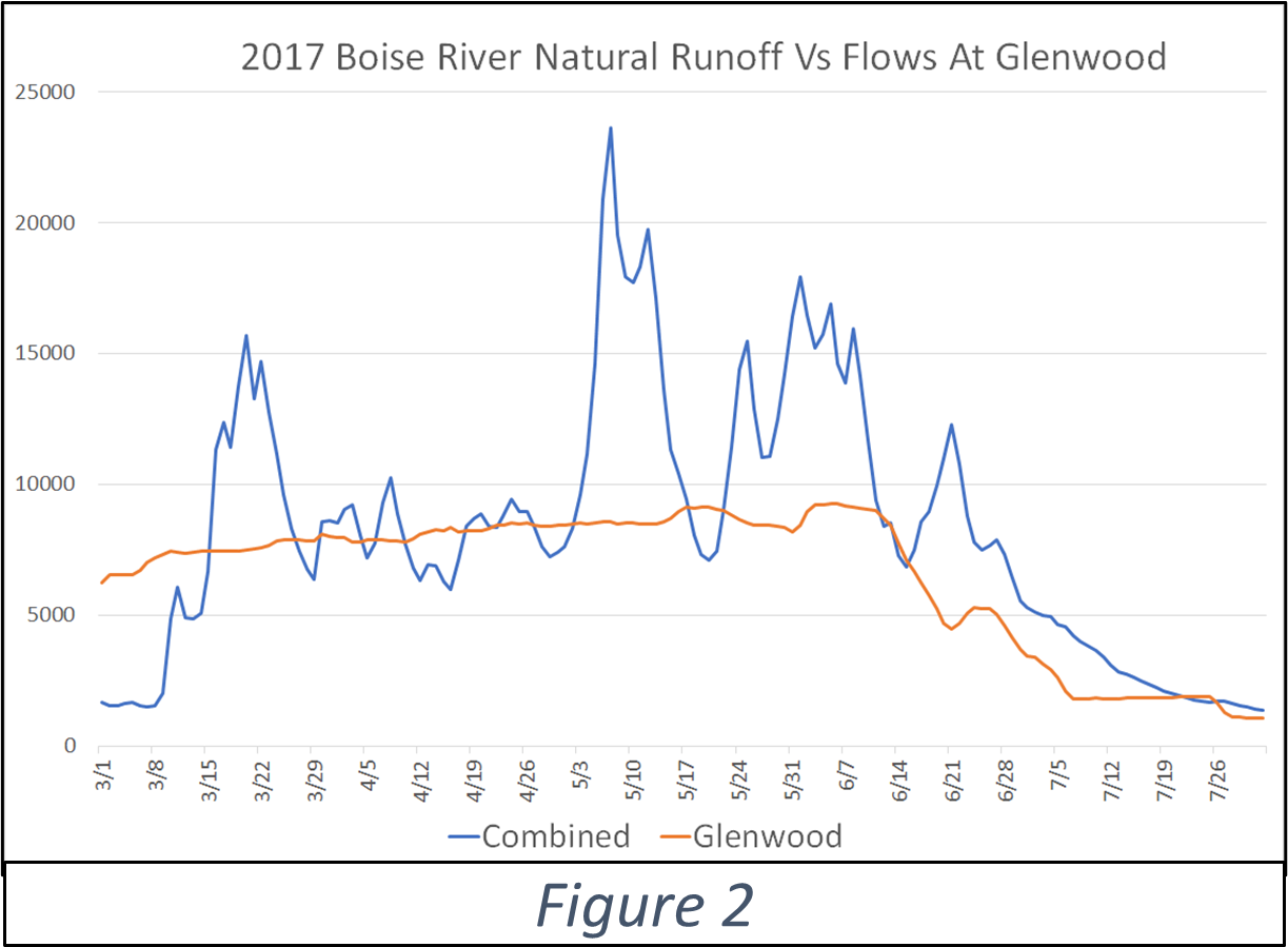
High flows on a Tailwater river tend to happen earlier in spring in order to make room in the reservoirs for the anticipated snowmelt. It is a calculated game of letting out just enough water to avoid flooding while capturing the maximum amount of water in the reservoirs. They are pretty good at managing flows to avoid major flooding—although it has been close a few times. Figure 2 shows runoff from the 2017 Snowmageddon year, and while flows on the Lower Boise River did exceed “bank full” flows of 6,500cfs and caused some minor flooding, the natural (undammed) combined flows of the N.F., M.F. and S.F. of the Boise rivers reached peaks of 15,000cfs – 24,000cfs which would have been a major flood event for Boise.
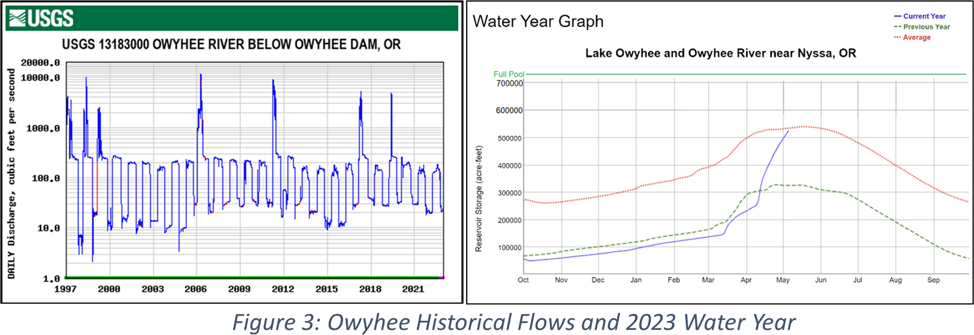
The Owyhee reservoir was sitting at 35% of capacity this winter (significantly below average) but has started to fill and is rising fast, as shown in Figure 3. Over the last 25 years the Lower Owyhee River has seen 7 years with high flows, but even though the Owyhee drainage had an excellent snowpack this year, Owyhee Reservoir had so little water carryover that it is unlikely that the lower Owyhee river will see high flows, which is too bad because that river could really benefit from higher flows to clean sediment left by side stream blowouts.
FREESTONE RIVERS AND SPRING CREEKS
Spring flows on freestone rivers like the M.F. Boise and the Wood River are 100% dictated by the snowpack and the weather. A quick warmup on a high snowpack year results in the highest flows, and with our high snowpack and cool spring there is likely to be some flooding when it finally warms up, so stay tuned to the BVFF Local Waters page and be careful. Spring Creeks can be a good place to escape high flows because they are not fed by runoff (make sure to check fishing regulations before you go to ensure it is open). Spring Creeks, such as Silver Creek, don’t see as significant range of flows, but high and low snowpack years do impact groundwater springs which changes flows some.
SPRING CLEANING
High spring flows are very healthy for a river: They clean out accumulated sediment which improves the river’s carrying capacity and keeps it connected to the floodplain. High flows clean and redistribute gravel for trout spawning, although rivers below a dam don’t get new gravel from upstream because it gets trapped behind the dam. Over time this limits the amount of wild trout spawning habitat, which is why we recently added gravel to the Boise River and are working to add gravel on the Owyhee. Luckily the S.F. of the Boise has some good tributaries that bring in gravel when they blow-out which periodically refreshes the spawning gravel on that river.
Removing accumulated sediment is good for insect life as well. For example, after high flows on the Owyhee, caddis and stonefly populations improve although some slow water insects like callibaetis mayflys get swept away and take a few years to recolonize. When planning your summer fishing trips keep in mind that high water years usually delay hatch timing because of the colder runoff, compared to low water years when rivers warm up sooner which accelerates hatches. For an example of how runoff impacts hatches see this month’s Bug Corner.
SIDE CHANNEL PROTECTION
As flows come up the Lower Boise River stays “in bank” until the river reaches 7,000cfs and the water gets very fast, compared to the Lower Owyhee River which comes out of bank quickly, spreads out and stays at a much lower velocity. High velocity flows are difficult for juvenile trout, especially brown trout fry that recently emerged from their redds/nests in March. Side channels provide refuge for trout to escape the hurtling velocities of the main river. Figure 4 shows the “BVFF Side Channel” on the Boise River at winter flows and at high runoff flows. While the main river is raging with little place for trout to hide, you can see numerous areas of softer water and good woody cover in the side channel where trout can hold. The location of our gravel augmentation is circled in the photo: We intentionally added it on an inside corner to protect it from higher flows and it will be interesting to see how much of it stays put and where Mother Nature decides she wants to relocate some of it. We will volunteer with IDF&G on their Fall Shoreline Fry Surveys again this Fall to evaluate the side channel gravel and see how the juvenile trout population fared.